A visit to Cape Town isn't complete without a lazy Sunday afternoon drive to Cape Point.
Few road trips in the world serve up such dramatic and diverse ocean views. On our way we pass Muizenberg.
 |
| The surfers beach viewed from Boyes Drive. |
and we continued on to Cape Point.
This section of Table Mountain National Park covers more than 19,000 acres. Much of the park consists of rolling hills covered with fynbos and laced with miles of walking trails.
A paved road runs twelve and a half kms to the tip of the peninsula, and a turnoff leads to the Cape of Good Hope, a rocky cape that is the southwestern most point of the continent!
A plaque marks the spot, otherwise you would never know you are standing on a site of such significance.
Probably the most photographed sign in South Africa which declares that the visitor posing behind the sign is standing at the most south-western point of the African continent! Which let's face it is pretty cool!
The opposite is true of Cape Point, a dramatic knife's edge of rock that slices into the Atlantic.
The walk up to the viewing platform and the old lighthouse is very steep - there is a funicular. We walked. It took 6 years, from 1913 to 1919, to build the old lighthouse, 816 feet above the high-water mark. On a clear day the old lighthouse was a great navigational mark, but when the mists rolled in it was useless, so a new and much lower lighthouse (286 feet) was built at Dias Lookout Point. The newer, revolving lighthouse is the most powerful on the South African coast and emits a group of 3 flashes every 30 seconds. It has prevented a number of ships from ending up on Bellows or Albatross Rock below. Stark reminders of the ships that didn't make it are dotted around the Cape, with some rusty remains on the beaches.
The second very commonly photographed sign is the directional sign-post at the viewpoint at the lighthouse.
Visitors just love knowing how far away home is!
Leaving Cape Point behind we decided to head for our favourite Sunday lunch of Calamari at Chapman's Peak Hotel. We passed some wonderful flame trees en route.
and Noordhoek Beach. One of the longest sandy stretches along Cape Point's coastline. It reaches all the way to Kommetjie. Dare a dip in the icy waters?!
Then on to Chappies, as Chapman's Peak Drive between Noordhoek and Hout Bay is more commonly known, is a motorist's heaven.
The drive, carved into the side of the mountain, was opened in the 1920s but closed in the 90s after several rockfalls. It is now in operation again after extensive construction work, including a series of concrete overhangs and steel netting designed to catch any pesky boulders. It's a toll road now but the R33 entry fee (for cars) is small change next to the view from the 9 km route with its 114 curves. www.chapmanspeakdrive.co.za
Lunch, as usual, at the Chapman's Peak Hotel overlooking Hout Bay was excellent.
Phil chose the dark chocolate Pannacotta
while I, of course, went for a Don Pedro. ALL GONE.
Another beautiful flame tree with Tabletop mountain in the background on our drive back to the Hotel.
On Monday Phil treated me to a one hour Cape Point Helicopter Flight.
"The Point" flight is the ultimate scenic tour covering the entire Cape Peninsula. From take-off you get a great view of The Football Stadium
and the V and A Waterfront Shopping Centre
We then routed along the coastline passing Sea Point and the Lions Head
Our hotel at Bantry Bay (The curved one with the pool).
Camps Bay
We had a great view of the famous Chapman's Peak Drive. The Cape Town icon that we drove along yesterday which curls sharply around the slopes overlooking the Atlantic Ocean while the steep cliffs tower to the left.
We followed the coast until Noordhoek Beach.
From here we continued south passing Kommetjie, Scarborough and Misty Cliffs.
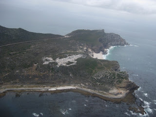
From this point we started flying over the Cape Point Nature Reserve.
Nearing the southern most point of the Peninsula we passed the Cape of Good Hope,
Dias Beach
and, of course, Cape Point itself. As we flew over the tip of the Peninsula we enjoyed never to be forgotton views of Cape Point and Cape of Good Hope. Such beautiful unspoilt, wild and rugged scenery.
After rounding the point (twice) we routed North with the grand vistas of False Bay unwinding as we flew up the coastline. From rocky mountain tops to beaches and open sea I was in total awe of it's beauty.
The famous Boulders Beach with its penguins. Can you see them?
We then passed Simon's Town, a naval base in the Cape and characterised by land that rises steeply from near the water's edge.
and Fish Hoek which used to be known as a dry zone, which means that the selling of alchohol was prohibited. You won't find a bottle store in town but you may see a great white shark or two close to it's sheltered beach according to our pilot!
After flying over the Constantia winelands we started our descent for the Waterfront Helipads.
and this romantic journey closes.


